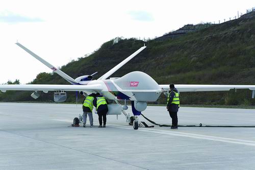
Maintenance personnel inspect Wing Loong-2 UAV.
By Yang Chen
GARZE, Mar. 20 -- A forest fire broke out in Baizi Village, Xiala Town of Yajiang County of Garze Xizang Autonomous Prefecture in southwest China's Sichuan Province at 5:00 pm on March 15, 2024. China's Ministry of Emergency Management emergently dispatched the Wing Loong-2 unmanned aerial vehicle (UAV) to undertake disaster reconnaissance and communications support for the disaster relief tasks.
The UAV Wing Loong-2 took off from Lantian Airport in Zigong city, Sichuan at 6:00 pm on March 18 to conduct emergency disaster relief task in Yajiang. It landed safely after 18 hours of flight, during which it carried out thorough reconnaissance of three fire-stricken areas, covering 1,200 square kilometers in total.
During the task, the Wing Loong-2, also served as an aerial base station, provided communications support for the disaster relief operations with 14 hours of effective communication signals.
The mountainous and steep terrain in the fire-stricken areas precluded the relief personnel from approaching and made reconnaissance a difficult task. Despite the complex conditions of low visibility at night and thick smoke, the UAV Wing Loong-2 completed multi-spectrum and all-round reconnaissance of three areas affected by the fire.
The UAV Wing Loong-2 sent the on-site data and high-definition images back to the emergency rescue command center in real time, enabling visual command and providing essential information for identifying risk points, monitoring the fire and adopting targeted rescue and fire-fighting measures.


