By Yuan Yufei
"China will complete the comprehensive construction of the BeiDou global system as scheduled in 2020," said Yang Changfeng, chief designer of BeiDou Navigation Satellite System (BDS), at the 8th Annual Meeting of China Global Navigation Satellite System (GNSS) and Location Based Service (LBS), videlicet China BDS Application Forum, held in Zhengzhou, Henan Province on Tuesday.
The theme of this conference is "BeiDou serves the world and integrates innovative applications". The basic system of BeiDou-3 has been completed and begun to provide global services on December 27, 2018. Since the beginning of this year, BeiDou has made great achievements in the world, especially in serving the Belt and Road Initiative.
BeiDou’s system positioning accuracy will be comparable to the Global Positioning System (GPS) developed by the US
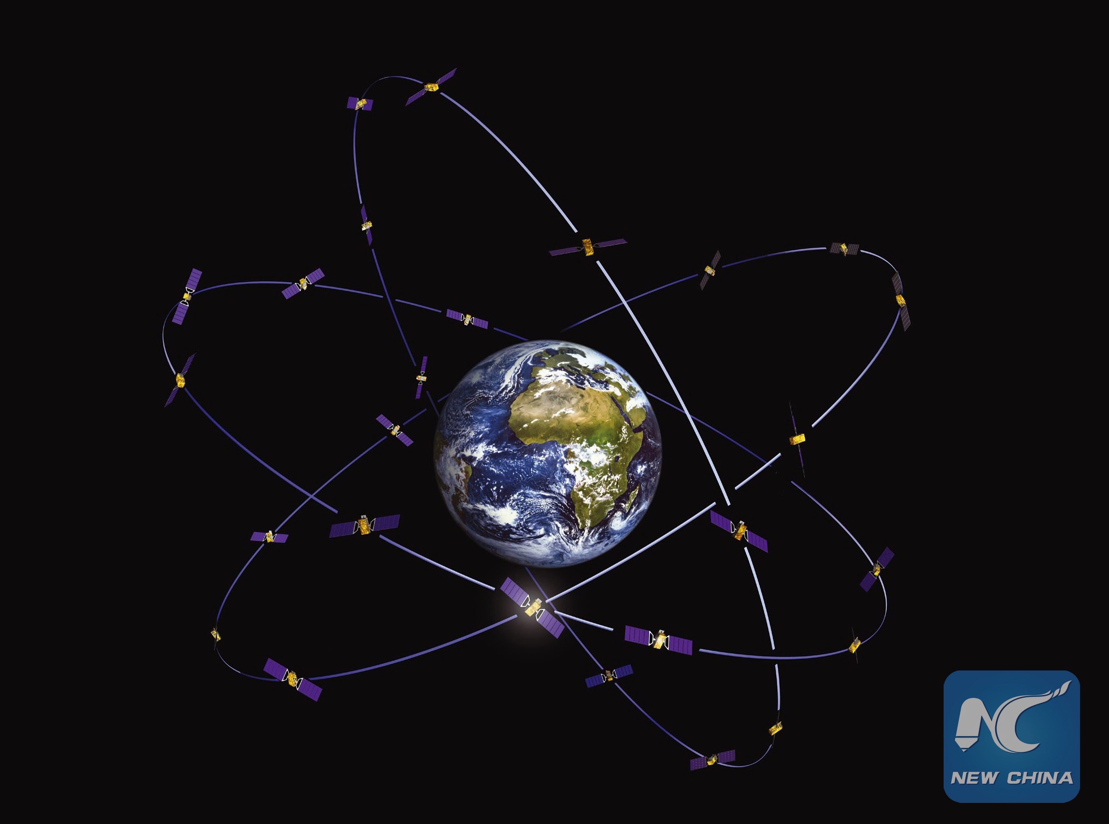
It is learned from the forum that at present, the BDS officially provides global services with 39 satellites in orbit, among which there are 21 BeiDou-3 satellites, specifically 18 in Medium Earth orbit (MEO), one in Geostationary Orbit (GEO) and two in Inclined Geosynchronous Orbit (IGO).
"The construction of the BeiDou project is progressing smoothly. Another five to seven satellites will be launched this year and two to four be launched next year. By then, the BDS construction will be fully completed. China's navigation, positioning and timing system will take BeiDou system as the core. In terms of new technology integration, BeiDou will have deep integration with the Internet, Internet of Things, 5G and big data, etc.," said Yang.
It is reported that as the BDS Ground-based Augmentation System becomes operational, it can provide meter, sub-meter, decimeter, and even centimeter-level services. The positioning accuracy of BDS will be comparable to the GPS of the US.
Extensive application in countries and regions along the Belt and Road Initiative
The completion of BeiDou-3’s basic system and the start of global service indicate that BeiDou has entered the global era two years ahead of schedule, playing a big role in serving the world, especially in countries and regions along the Belt and Road.
"Countries and regions along the Belt and Road have relatively large demands for satellite navigation. We will explore the potential of using BDS in those countries. On the one hand, we will empower these industries or products to promote local economic development. On the other hand, we can expand BeiDou’s global market," said Yu Xiancheng.
BDS has covered nearly 30 countries along the Belt and Road, including Pakistan, Saudi Arabia and Myanmar. The agricultural, industrial and service sectors in these countries are gradually using high-precision BeiDou products, said Yu.
For example, the Ministry of Land and Spatial Planning of Indonesia used BDS to carry out land rights projects, using more than 1,000 Beidou-based high-precision GNSS receivers. In Cambodia, UAVs, for which the BDS provides navigation and positioning services, have a wide range of applications and high efficiency in mapping as it provides complete basic information for comprehensive planning, land consolidation monitoring, infrastructure construction, and ecological environment monitoring conducted by the Cambodian government.
Pakistan started to use BeiDou products long time ago. BDS has been providing services in areas such as port management and transportation in Pakistan. The first overseas networking project of BDS, the first Phase of the Pakistan National Positioning Service Network, was completed, which is a model of intensive cooperation between China and Pakistan in satellite navigation. In Africa, the Land Surveying and Mapping Department of Uganda has built 15 base stations using high-precision receivers. The high-precision location services provided by BeiDou can not only meet the needs of Uganda's land surveying and mapping, but also expand into water conservancy, transportation, agriculture, forestry and other fields.
"BeiDou provides basic navigation services to countries and regions along the Belt and Road and has taken a key step from regional to global," said Yang. BDS integrates navigation, positioning, timing and short message communication services into one, and on this basis, increases the service capabilities including international search and rescue, satellite-based enhancement, and precise single-point positioning. Moreover, BDS has achieved compatible interoperability with US's GPS and Russia's GLONASS.
China's satellite navigation industry will exceed 400 billion yuan by 2020
It is learned from the forum that BeiDou is now more than a business card of China, the application of which has become a strategic emerging industry with a global market.
Yu introduced that the application of the application of BDS has become an economic growth point of strategic emerging industries. With the opening of global service and the establishment of BeiDou-3 system as an opportunity, China will continue to promote the integration and innovation of BDS. BeiDou will also usher in a golden period of deepening application. According to the current growth rate, it is estimated that the scale of China's satellite navigation industry will exceed 400 billion yuan by 2020.